Weiden in der Oberpfalz
This article needs additional citations for verification. (September 2023) |
Weiden in der Oberpfalz | |
|---|---|
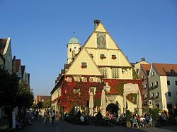
 Old Town Hall | |
| Coordinates: 49°40′N 12°09′E / 49.667°N 12.150°E | |
| Country | Germany |
| State | Bavaria |
| Admin. region | Upper Palatinate |
| District | Urban district |
| Government | |
| • Lord mayor (2020–26) | Jens Meyer[1] (SPD) |
| Area | |
• Total | 68.50 km2 (26.45 sq mi) |
| Elevation | 397 m (1,302 ft) |
| Population (2023-12-31)[2] | |
• Total | 43,188 |
| • Density | 630/km2 (1,600/sq mi) |
| Time zone | UTC+01:00 (CET) |
| • Summer (DST) | UTC+02:00 (CEST) |
| Postal codes | 92637 |
| Dialling codes | 0961 |
| Vehicle registration | WEN |
| Website | www.weiden.de |
Weiden in der Oberpfalz (official abbreviation: Weiden i.d.OPf.; Northern Bavarian: Weidn in da Owapfalz) is a district-free city in Bavaria, Germany. It is located 100 km (62 mi) east of Nuremberg and 35 km (22 mi) west of the Czech border. Weiden is the second biggest city in the governmental district Oberpfalz, next to Regensburg. A branch of the German Army is located here.
History
[edit]Weiden in der Oberpfalz was first mentioned in a document in 1241 as Weiden. It is assumed that the first settlements in Weiden are dated the year 1000. Located at the intersection of two major trading routes (Goldene Strasse and Magdeburger Strasse), Weiden soon became an important trading center with a population of 2,200 in 1531. Two city fires, the Thirty Years' War and the Plague gave the city setbacks, which it didn't recover from until the end of the 18th Century. Between 1634 and 1635, as well as between 1648 and 1650; Weiden was occupied by Swedish troops. Since 1714 the city fully belonged to the Duchy of Palatine-Sulzbach. An economic boom came along in 1863, when Weiden was connected to the railroad network. With the settlement of important glass and porcelain companies, the population increased, around the turn of the century it was already close to 10.000.
On 1 January 1919, the city became district-free by decree of the first Republican Prime Minister, Kurt Eisner (USPD)
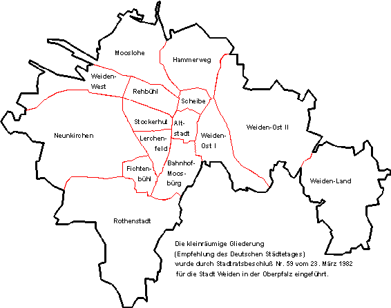
Districts
[edit]
| Nr. | District | Area
(km2) |
Population | Remarks | Population density
(People per km2) |
|---|---|---|---|---|---|
| 01 | Altstadt | 0.98 | 3.943 | Southern old town with historic city center | 4023 |
| 02 | Scheibe | 0,86 | 2.296 | Northern old town | 2669 |
| 03 | Hammerweg | 4,32 | 5.559 | 1286 | |
| 04 | Weiden-Ost II | 10,45 | 2.829 | with Tröglersricht, Zollhaus, Almesbach | 270 |
| 05 | Weiden-Ost I | 3,14 | 2.490 | 792 | |
| 06 | Bahnhof-Moosbürg | 2,55 | 1.466 | 574 | |
| 07 | Fichtenbühl | 1,27 | 1.192 | with Ermersricht | 938 |
| 08 | Stockerhut | 1,80 | 3.953 | 2196 | |
| 09 | Lerchenfeld | 1,45 | 4.459 | 3075 | |
| 10 | Weiden-West | 5,03 | 2.062 | with Brandweiher | 409 |
| 11 | Rehbühl | 1,53 | 6.538 | 4273 | |
| 12 | Mooslohe | 5,50 | 3.559 | with Moosöd | 647 |
| 13 | Neunkirchen | 11,50 | 1.718 | with Frauenricht, Latsch, Halmesricht, Spitalöd, Wiesendorf | 149 |
| 14 | Rothenstadt | 11,73 | 3.145 | with Ullersricht, Neubau, Maierhof, Mallersricht, Mallersricht-Ziegelhütte | 268 |
| 15 | Weiden-Land | 8,43 | 235 | with Muglhof, Matzlesrieth, Unterhöll, Mitterhöll, Trauschendorf, Oedenthal | 27 |
Incorporations into Weiden in der Oberpfalz
[edit]On January 1, 1914, the municipality of Moosbürg was incorporated with Moosbürg, Ermersricht, Fichtenbühl and Leihstadtmühle. On February 1, 1915 Tröglersricht and Zollhaus of the former municipality of Edeldorf followed
On July 1, 1972 the following districts were incorporated:
- Municipality of Frauenricht with Frauenricht, Halmesricht, Latsch and Spitalöd
- Municipality of Muglhof with Muglhof, Mitterhöll, Unterhöll, Oedenthal and Trauschendorf
- Municipality of Neunkirchen bei Weiden with Neunkirchen, Brandweiher and Wiesendorf
- Municipality of Rothenstadt with Rothenstadt and Mallersricht
On May 1, 1978 the following districts were added to existing Municipalities
- Matzlesrieth; added to the Municipality of Muglhof
- Maierhof, Neubau, Ullersricht and Moodöd; added to the Municipality of Rothenstadt
Main sights
[edit]Historical buildings
[edit]- St. Josef. Catholic church, built 1899–1900, Neo Romanesque style with Art Nouveau interior.
- Marktplatz, the market square stretched between Upper and Lower Gates with numerous renaissance buildings.
- Altes Rathaus ("Old Town Hall"), built between 1539 and 1545 by Hans Nopl.
- St. Michael. A Protestant church, rebuilt several times. The church got its present baroque appearance from 1627, the tower from 1761.
- Alte Stadtmauer, partially preserved old city walls from the 14th century.
- St. Sebastian Kirche. Catholic chapel, built around 1480.
Museums
[edit]- International Ceramic Museum
- City Museum - exhibits art, furniture and porcelain from the early 16th century to the 19th century. There is a room dedicated to composer Max Reger, who lived and studied in Weiden.
Economy and Infrastructure
[edit]Overview
[edit]In the year 2016, Weiden, within the city limits, reached a GDP of 2.272 Billion € and a GDP per capita of €53.734 . (Bavaria: 44.215€/ Germany: 38.180€) Therefore it was significantly higher than average. In 2017 there were about 41.800 employeed people in the city. The rate of unemployment in 2018 stood at 5.3%, and therefore significantly higher than the bavarian average of 2.7%.
Economic structure
[edit]Today, about 42.000 people live in Weiden on an Area of 70.5 km2 / 27.2 mi2. Weiden never was a typical industrial city; in 2015 only a fifth of all 26.567 employees subject to social security worked in the manufacturing sector, meanwhile more than ¾ were working in the service sector.
Since the end of the 20th century industry and trade have changed a lot. The monostructure of glass and porcellain with companies like Bauscher, Seltmann and Nachtmann, who still play a big role in the manufacturing sector, was dismantled and supplemented through vehicle construction, plastics processing and microelectronics companies.
A structural change is reflected in the massive job cuts in the glass and porcelain industry, which is why Weiden suffers from persistently high rates of unemployment.
Traffic
[edit]Highways
[edit]- Bundesautobahnen:
- A93: Autobahndreieck Hochfranken - Hof - Weiden - Schwandorf - Regensburg - Wolnzach - Autobahndreieck Holledau
- Bundesstraßen:
- B22: Würzburg - Bayreuth - Weiden - Cham
- B470: Bad Windsheim - Forchheim - Auerbach i.d.OPf. - Weiden
Public transit
[edit]The city buses are operated by the company Wies. There are 7 bus lines in regular traffic (Line 1-7) and 6 bus lines in light traffic (91-95, 98), that all meet at the Central Bus Station next to the town hall. The regular traffic (in which buses drive every 15-30 minutes) applies every Monday to Friday between 6:00 and 18:15. Before 6:00 and after 18:15, as well as on Saturdays, Sundays and national holidays the light traffic (with buses every 40 minutes) applies.
Next to the citybuses, there are intercity buses operated by the Regionalbus Ostbayern GmbH (RBO), a daughter company of the Deutsche Bahn. They drive into the surrounding cities and villages and meet at the cities' train station
Ticket prices are regulated by the Tarif Oberpfalz Nord (TON). The Nahverkehrsgemeinschaft Weiden-Neustadt (NWN) has joined the TON as well, creating one unified system for the northern part of the Oberpfalz
Twin towns – sister cities
[edit]Weiden in der Oberpfalz is twinned with:[3]
 Issy-les-Moulineaux, France (1962)
 Macerata, Italy (1963)
 Weiden am See, Austria (1990)
 Annaberg-Buchholz, Germany (1990)
 Mariánské Lázně, Czech Republic (2008)
Geography
[edit]Climate
[edit]This area is characterized by equable climates with few extremes of temperature and ample precipitation in all months. The Köppen Climate Classification subtype for this climate is "Cfb". (Marine West Coast Climate).[4]
| Climate data for Weiden in der Oberpfalz (1991–2020 normals) | |||||||||||||
|---|---|---|---|---|---|---|---|---|---|---|---|---|---|
| Month | Jan | Feb | Mar | Apr | May | Jun | Jul | Aug | Sep | Oct | Nov | Dec | Year |
| Mean daily maximum °C (°F) | 1.9 (35.4) |
3.7 (38.7) |
8.5 (47.3) |
14.3 (57.7) |
18.8 (65.8) |
22.2 (72.0) |
24.2 (75.6) |
24.0 (75.2) |
18.7 (65.7) |
12.8 (55.0) |
6.3 (43.3) |
2.5 (36.5) |
13.2 (55.8) |
| Daily mean °C (°F) | −0.6 (30.9) |
0.2 (32.4) |
4.0 (39.2) |
8.7 (47.7) |
13.2 (55.8) |
16.5 (61.7) |
18.3 (64.9) |
18.0 (64.4) |
13.3 (55.9) |
8.5 (47.3) |
3.6 (38.5) |
0.3 (32.5) |
8.7 (47.7) |
| Mean daily minimum °C (°F) | −3.2 (26.2) |
−3.1 (26.4) |
−0.2 (31.6) |
3.2 (37.8) |
7.3 (45.1) |
10.6 (51.1) |
12.5 (54.5) |
12.1 (53.8) |
8.3 (46.9) |
4.7 (40.5) |
1.0 (33.8) |
−2 (28) |
4.3 (39.7) |
| Average precipitation mm (inches) | 52.7 (2.07) |
39.8 (1.57) |
47.1 (1.85) |
36.7 (1.44) |
66.5 (2.62) |
81.1 (3.19) |
80.5 (3.17) |
70.1 (2.76) |
57.9 (2.28) |
54.8 (2.16) |
52.8 (2.08) |
59.5 (2.34) |
701.5 (27.62) |
| Average precipitation days (≥ 1.0 mm) | 16.6 | 14.6 | 15.1 | 12.4 | 14.2 | 14.3 | 15.4 | 12.6 | 12.7 | 14.9 | 15.6 | 18.2 | 176.7 |
| Average snowy days (≥ 1.0 cm) | 12.8 | 12.9 | 5.1 | 0.2 | 0 | 0 | 0 | 0 | 0 | 0 | 3.2 | 8.4 | 42.6 |
| Average relative humidity (%) | 86.8 | 82.1 | 76.4 | 69.0 | 69.3 | 69.7 | 69.3 | 70.7 | 78.2 | 84.3 | 89.1 | 89.5 | 77.9 |
| Mean monthly sunshine hours | 45.7 | 75.3 | 120.3 | 179.2 | 206.4 | 208.8 | 225.2 | 217.3 | 157.7 | 104.7 | 45.1 | 33.5 | 1,619.2 |
| Source: World Meteorological Organization[5] | |||||||||||||
Notable people
[edit]- Erhard Weigel (1625–1699), astronomer and mathematician
- Franz Ferdinand von Rummel (1644–1716), Prince-Bishop in Vienna
- Max Reger (1873–1916), composer and organist
- Eduard Zintl (1898–1941), chemist
- Otto Ambros (1901–1990), chemist and a Nazi war criminal
- Martin Gottfried Weiss (1905–1946), SS Commander of German concentration camps executed for war crimes
- Elisabeth Schärtel (1919–2012), mezzo-soprano
- Erich Bäumler (1930–2003), footballer
- Marga Schiml (born 1945), opera singer
- Monika Henzinger (born 1966), computer scientist
- Michael Brenner (born 1964), historian
- Benedikt Schopper (born 1985), ice hockey player
- Sandro Schoenberger (born 1987), professional ice hockey player
- Nadine Kraus (born 1988), footballer
- Sven Kopp (born 1995), footballer
- Dennis Lippert (born 1996), footballer
See also
[edit]Important glass and porcellain companies in Weiden
[edit]Notes
[edit]- ^ Liste der Oberbürgermeister in den kreisfreien Städten, accessed 19 July 2021.
- ^ Genesis Online-Datenbank des Bayerischen Landesamtes für Statistik Tabelle 12411-003r Fortschreibung des Bevölkerungsstandes: Gemeinden, Stichtag (Einwohnerzahlen auf Grundlage des Zensus 2011).
- ^ "Partnerstädte". weiden.de (in German). Weiden in der Oberpfalz. Retrieved 2021-02-17.
- ^ "Weiden, Germany Köppen Climate Classification (Weatherbase)". Weatherbase. Archived from the original on 4 March 2016. Retrieved 24 April 2018.
- ^ "World Meteorological Organization Climate Normals for 1991–2020". World Meteorological Organization Climatological Standard Normals (1991–2020). National Oceanic and Atmospheric Administration. Archived from the original on 12 October 2023. Retrieved 13 October 2023.


